Abstract
The research aims to develop an automated forest fire monitoring and alert system using unmanned aerial vehicles (UAVs) combined with artificial intelligence (AI) and Internet of Things (IoT) technology. The main goal is to build a remote monitoring and fire detection system using UAVs that transmit images. Through machine learning models, the system will detect and record fire incidents and pinpoint their locations to facilitate timely extinguishment, thus reducing damage and enhancing response effectiveness. Specifically, the project involves: Developing a UAV controlled by a handheld device; Creating a mobile application capable of live image streaming using Amazon IVS and locating and transmitting the device's position via MQTT protocol; Building a management application to display live images from the UAV, show the device's flight path on a map, and record fire incidents; Training a machine learning model using YOLO v5 to detect fire and smoke for timely forest fire detection.
Introduction
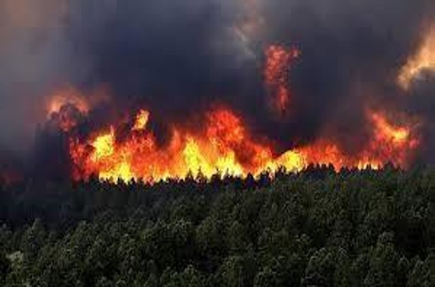
Bushfires are a significant issue in Vietnam and globally, causing substantial damage to the environment, economy, and human health. In Vietnam, bushfires commonly occur during the dry season and have historically caused significant damage, though the area burned has decreased in recent years. Globally, bushfires affect not only tropical forests but also temperate regions, leading to severe impacts on people, property, and climate.
The project "Development of an Automatic Forest Fire Monitoring and Warning System Based on Drones Using Artificial Intelligence and IoT" aims to create an effective remote monitoring system for detecting and alerting about bushfires . The system will utilize drones to capture images, AI to detect fires early, and IoT to transmit data and provide location information. Specific goals include developing drone equipment, mobile and management applications, and training the YOLO v5 machine learning model to identify fire and smoke. This system will help protect the environment and property, while also reducing costs and resources in wildfire prevention efforts.
Proposed Method
In the proposed model, it is clear that the system will consist of three main components, including devices, AWS services, and a web management application. Each component will play a crucial role in ensuring the system operates stably.
The device includes a drone with supporting components such as GPS, a camera, and GSM. These components can be replaced by an Android mobile device with network connectivity, programmed to send location data via MQTT and images through AWS's IVS service. The drone transmits live images and current location coordinates via telecommunication networks to the web management application. The images are uploaded to IVS and streamed via video. The management application receives images from IVS and uses a machine learning model to detect fire or smoke. If detected, the system logs the event and displays labeled images; if not, it only shows the live feed. Location data is sent via MQTT and displayed on Google Maps with the drone's current position and flight path.

Building a problem:
- Hardware Assembly involves:
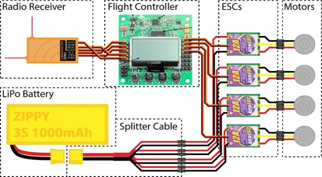
System Safety: Use high-quality, appropriately sized wires, and ensure secure connections between the battery, motors, and flight controller.
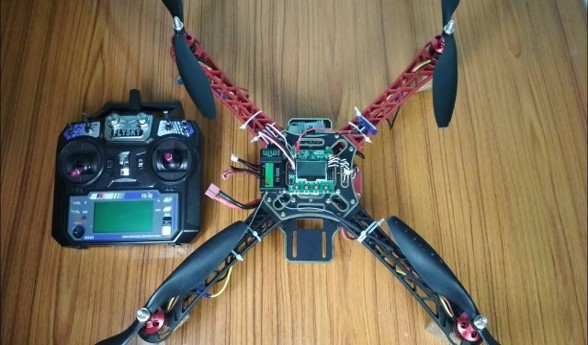
Assembly: Attach the motors and propellers securely to the frame, ensuring propeller balance and proper placement. Position the flight controller at the center of the frame, connect signal and power wires correctly, and secure the battery.
Inspection and Balancing: Ensure all connections and screws are tight, check that propellers and motors are undamaged, and balance the drone by adjusting its center of gravity if needed.
Implementation of IVS services:
- Step 1: Log in to AWS and select the IVS service.
- Step 2: Install and configure the IVS service.
- Step 3: Record important information, including the RTMP server, stream key, and playback setup.
Deploy MQTT Service:
- Step 1: Add the installation libraries to the configuration file.
- Step 2: Declare important information such as MQTT broker, MQTT topic, etc.
- Step 3: Set up the feature of sending the device's location through the broker and the declared topic and build an application interface to perform the function of retrieving and sending the device's location.
- Step 4: Check the app's activity
Fire identification and detection training: A fire detection model has two stages:
- Data Processing: Preparing and preprocessing the dataset.
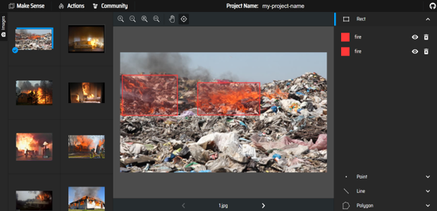
+ Step 1: Upload image datasets to the processing tool
+ Step 2: Assign labels to objects in the image, assigning labels to objects in the image will be done manually through scanning the blocks for the objects to be identified in the image.
+ Step 3: Collect the labeled dataset. Once labeling is complete, the website will support exporting the dataset with labels corresponding to images. Labeled data may be in .txt or .xml files, depending on individual programming. After obtaining the dataset, proceed to the training step.
- Model Training: Training the model using the processed data.
+ Step 1: Set up the YOLO v5 environment.
+ Step 2: Upload the dataset to Colab and adjust the training configuration file.
+ Step 3: Train the model, to be able to train the model, it is necessary to provide full information such as epochs, weight, data. After the training process, 2 model files will be obtained, namely file best.pt and last.pt
Results
After training the model, we obtain the following training charts:
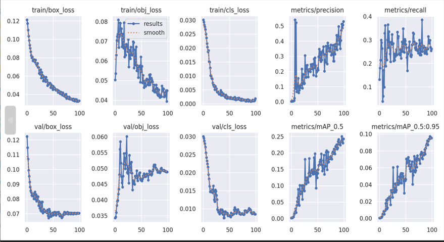
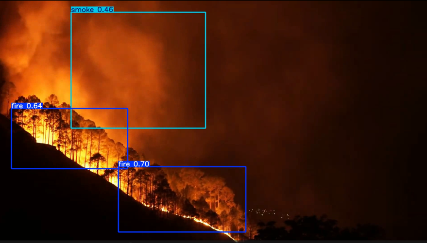
Through the testing process, it can be seen that the model after training can detect fire and smoke through images, thereby helping to ensure the model's ability to recognize and detect fire.
Conclusions
Through the implementation process, the project has achieved several key results: a drone was developed with all necessary components and is capable of taking off; an application was created to send the device’s GPS location data via the MQTT protocol; another application was utilized to stream live images through AWS's IVS service; a fire and smoke detection model was trained using YOLO v5; and a web-based management application was built to manage devices and events, display live video streams, and show the device’s flight path on a map.
References
- Thi-Thuy-Nga NGUYEN (2022), “Communication Solutions in UAV Swarms for Forest Fire Surveillance and Warning”.
- Phuong-Linh NGUYEN (2022), “Research on Coordinate Systems Used in Unmanned Aerial Vehicle (UAV) Technology”.
- Chi Yuan; Zhixiang Liu; Youmin Zhang (2017), “Fire detection using infrared images for UAV-based forest fire surveillance”.
- Zhentian Jiao; Youmin Zhang; Jing Xin; Lingxia Mu; Yingmin Yi; Han Liu; Ding Liu (2019), “A Deep Learning Based Forest Fire Detection Approach Using UAV and YOLOv3”.
- Muhammad Yeasir Arafat, Muhammad Morshed Alam and Sangman Moh (2023), “Vision-Based Navigation Techniques for Unmanned Aerial Vehicles: Review and Challenges”.
- Khaled Telli, Okba Kraa,Yassine Himeur, Abdelmalik Ouamane, Mohamed Boumehraz, Shadi Atalla and Wathiq Mansoor (2023), “A Comprehensive Review of Recent Research Trends on Unmanned Aerial Vehicles (UAVs)”.
- Junhai Luo, Yuxin Tian and Zhiyan Wang (2024), “Research on Unmanned Aerial Vehicle Path Planning”.
- Pei Shi, Jun Lu, Quan Wang, Yonghong Zhang, Liang Kuang, Xi Kan (2023), “An Efficient Forest Fire Detection Algorithm Using Improved YOLOv5”.